
Product Overview
This system is mainly oriented towards municipal and district-level police users, realizes the collection and convergence of basic data within the administrative area, such as actual population, actual housing, actual units and actual security facilities, integrates the dynamic sensory data of community monitoring system, access control system, human face system, micro monitory gateway system, fire prevention system and other types of systems, and achieves the public security business application in the management on registered population, floating population, key person of the community, study & judgment on the traces of person and vehicle, and abnormal warning analysis, with the fight, prevention, management and control businesses at the center.
Technical Features
Getting through multiple networks
The system gets through relevant data in the local area network of the community, internet, extranet of government affairs, police image network and police information system through gateway and security switching equipment.
Data aggregation and sharing
The system aggregates the sensory data of the community through video and data access gateway, pushes the same to the police image network and extranet of government affairs for data sharing. The data access service aggregates police and government data resources, and carries out data analysis and other intelligent application at the police image network and extranet of government affairs.
Deep data mining
Based on the big data analysis technology, the system realizes the deep mining and application of massive data of the community, classifies, clusters, associates and predicts data via figure calculation, deep learning and other technologies. It achieves the arrangement of internal rules hidden in data and difficult to be found, and extracts potential valuable information from it.
Closing the cycle of warning disposal
The system perceives warning information, and analyzes warning in an intelligent manner. Local police station, community comprehensive governance office will handle the information according to different disposal strategies, give feedback about the disposal results, and form the closed cycle of business application.
Functions & Peculiarities
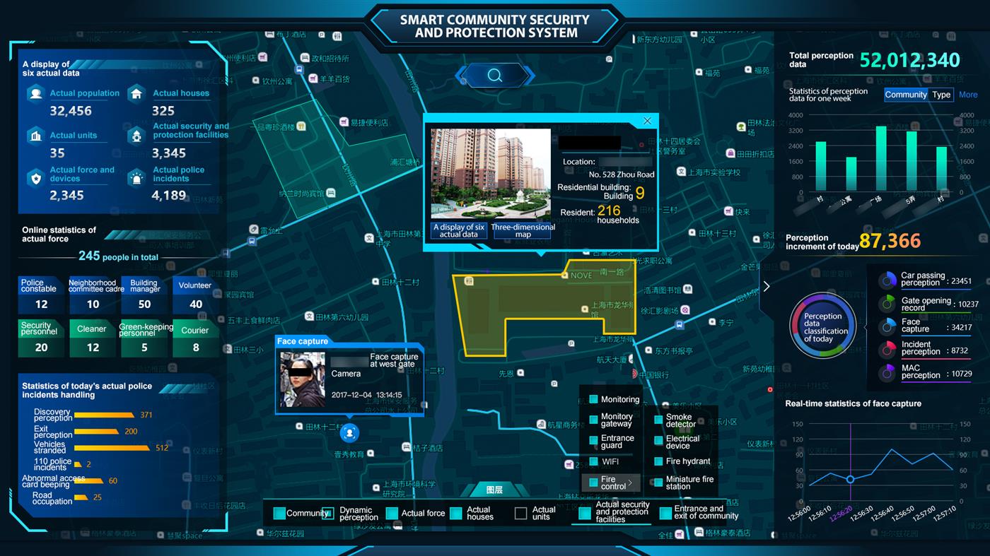
Smart community
The function presents the general conditions about the current system construction, including the stock-taking of the total quantity of data of "one standard and six actual figures", online actual security forces, total quantity and increment of sensory data, as well as the presentation thereof on the map; and the function can inquire, position individual communities, and enter into the detail page of "one standard and six actual figures" of corresponding communities.

One standard and six actual figures
The function demonstrates the position and information of actual population, actual housing, actual units, actual security facilities, and actual security forces within a community on the map through the unified standard address library; when an actual event occurs, the function will give a real-time warning and demonstrate the corresponding position on the map; it obtains real-time data and provides dynamic demonstration through human face, vehicle passage, door opening, fire prevention, video and other kinds of sensory resources.
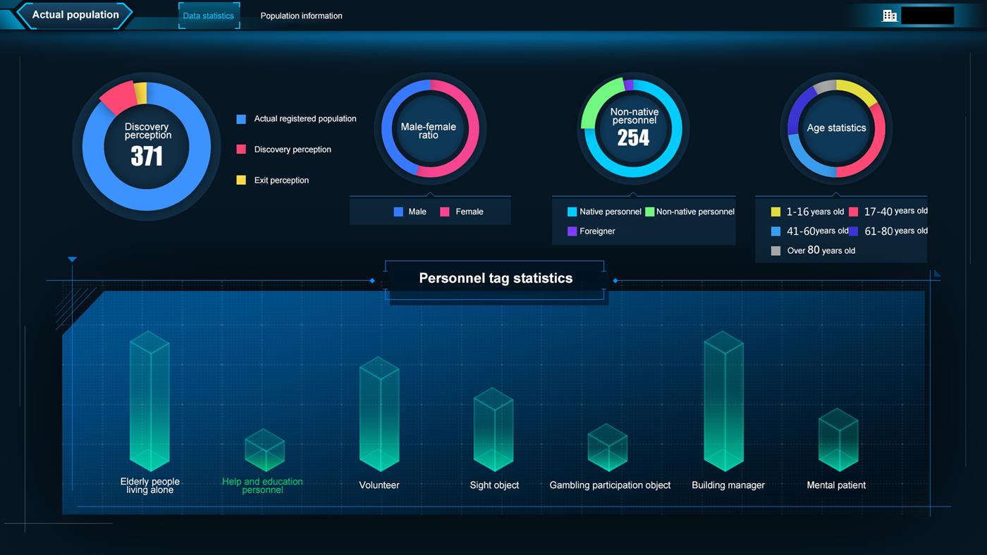
Actual population
It demonstrates the conditions of actual population in the community via various visualized charts based on the statistical methods of gender distribution, household register proportion, age distribution, personnel tag and other dimensions, and supports the query of person of the community through condition-based screening to look over the "one person one record ".
Actual housing
It provides a three-dimensional demonstration of the buildings of the community by floor and by household, including the housing property of every household (self-occupation, for rent, idle) and whether every household has person with specific tag (such as elderly people), and can further look into the "one housing one record ".

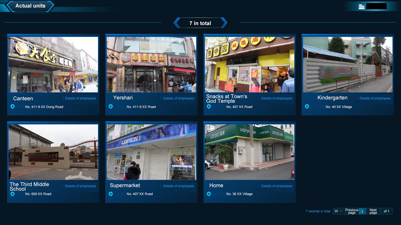
Actual units
The function can look into the detailed information of actual units within and surrounding the community, including the name, photo and address of the units, find the details of the employees of every unit, and support the demonstration of the position on the map.
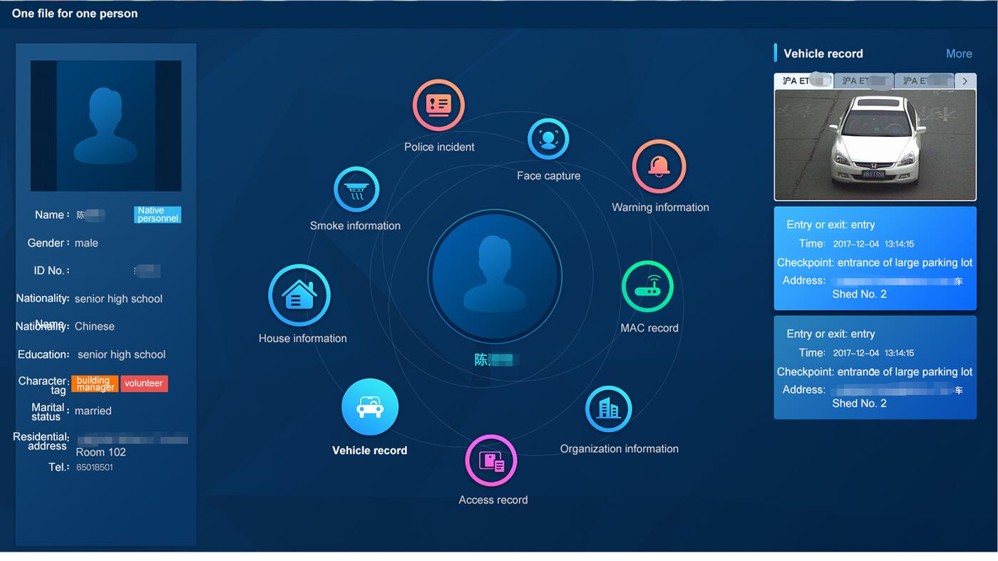
One person one record
It includes the photo, basic information and tag information of the person, and the housing, vehicle, human face snapshot, door opening record, warning event and other relevant information of the person. This function effectively assists community police to comprehensively understand and dynamically follow up various information of the person of the community.
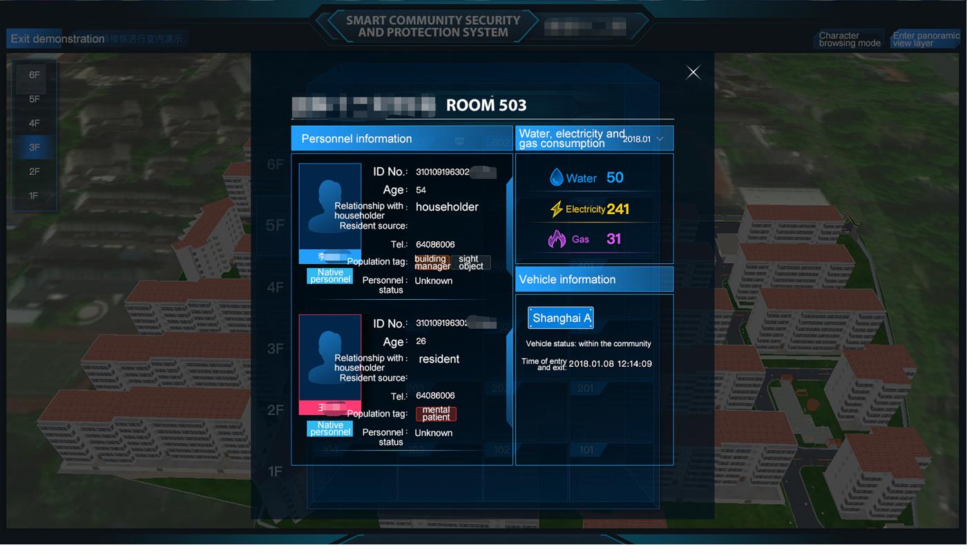
One housing one record
It indicates the comprehensive information of a household, including the list of all members living in the household, relationship of every person with the householder, monthly water, electricity and coal consumption, and vehicle information of the household, etc.
Trace depiction
By inputting a human face photo, dynamic sensory data and vehicle license plate number, it sees about the passage record within a given time frame, demonstrates the same on the map in a chronological order, and precisely depicts the activity traces of the object.
